
While drone technology has transformed the way data is collected, the true value of aerial surveys lies not merely in capturing photographs but in converting those images into meaningful engineering information. Every drone mission generates thousands of high-resolution photographs, videos, geographic coordinates, and sensor measurements that, when processed correctly, become powerful decision-making tools. At MAPPA Consultants, UAV Data Processing forms the foundation of our end-to-end drone solutions, enabling organizations to transform raw aerial data into highly accurate digital models, engineering drawings, analytical reports, and geospatial datasets that support planning, design, construction, monitoring, and long-term asset management.
The process begins immediately after every flight mission is completed. All captured data is carefully transferred from the drone’s storage systems to secure processing workstations, where it undergoes rigorous quality verification before analysis begins. Our specialists examine image clarity, GPS accuracy, overlap percentages, exposure consistency, camera calibration, and flight coverage to ensure that the collected dataset meets the technical standards required for precise processing. Any inconsistencies identified during this stage are carefully evaluated before moving to the next phase, ensuring that the final deliverables maintain the highest levels of accuracy and reliability.
One of the most important technologies used within UAV data processing is photogrammetry. This scientific process transforms hundreds or even thousands of overlapping aerial photographs into precise three-dimensional digital representations of the surveyed area. Sophisticated software identifies millions of common reference points between individual photographs and mathematically reconstructs the physical environment with exceptional precision. The result is a highly detailed digital model that accurately represents the terrain, structures, vegetation, roads, utilities, and other physical features within the project site. These digital models become valuable resources for engineers, architects, surveyors, planners, and government authorities responsible for making critical infrastructure decisions.
Among the most widely used outputs generated through photogrammetry is the orthomosaic map. Unlike ordinary aerial photographs, orthomosaic maps are geometrically corrected to eliminate perspective distortion and terrain displacement. Every pixel within the map corresponds to its exact geographical location, allowing users to perform highly accurate measurements directly from the digital image. Engineers can calculate distances, determine surface areas, identify existing infrastructure, evaluate land use, and monitor project progress without requiring repeated site visits. Orthomosaic maps have become essential tools for construction planning, land administration, environmental monitoring, agriculture, mining, transportation, and urban development because they provide accurate visual information within an easily accessible digital format.
Another important product generated through UAV data processing is the Digital Elevation Model (DEM), which represents the bare earth surface after removing buildings, vegetation, and other above-ground features. Digital Elevation Models provide engineers with valuable information regarding terrain elevation, slopes, drainage patterns, watershed analysis, flood modelling, and earthwork planning. Infrastructure designers rely heavily upon DEMs when planning highways, railways, irrigation systems, pipelines, and large industrial developments because they accurately represent natural ground conditions before construction begins. By understanding the terrain in greater detail, project teams can optimize designs, reduce excavation costs, and minimize environmental impacts during construction.
Closely related to the DEM is the Digital Surface Model (DSM), which represents the elevation of everything visible on the Earth’s surface, including buildings, trees, utility structures, and vegetation. Unlike the DEM, which focuses solely on ground elevation, the DSM provides a comprehensive representation of the actual environment as captured during the drone survey. This information becomes particularly valuable for telecommunications planning, urban development, renewable energy projects, aviation studies, and infrastructure design, where understanding the height of existing structures is essential for accurate planning and risk assessment.
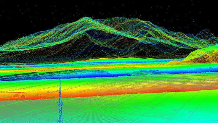
Another highly valuable output produced by MAPPA Consultants is the three-dimensional point cloud. Point clouds consist of millions of precisely positioned coordinate points that collectively recreate the surveyed environment in extraordinary detail. Every point contains spatial information representing the exact location of physical objects, allowing engineers to visualize complex structures from virtually any angle. These datasets are extensively used within architecture, engineering, construction, mining, heritage conservation, and industrial inspection because they provide exceptionally accurate digital representations suitable for advanced modelling, measurement, and analysis.
Three-dimensional models generated from drone data have become indispensable tools across multiple industries. Instead of relying solely on two-dimensional drawings, organizations can now explore virtual representations of project sites before construction begins. Engineers can visualize terrain conditions, evaluate design alternatives, identify potential conflicts, and communicate project concepts more effectively to stakeholders. Construction companies use these models to monitor progress, compare completed work against design specifications, and identify deviations that may require corrective action. Similarly, mining companies utilize three-dimensional models to evaluate excavation progress, calculate extraction volumes, and optimize operational planning with greater confidence.
One of the greatest strengths of UAV data processing lies in its ability to support accurate volumetric analysis. Earthmoving contractors, mining organizations, quarry operators, waste management facilities, and construction companies frequently require precise calculations of material quantities for inventory management, billing, production planning, and operational reporting. Traditional measurement methods often involve manual surveys that require significant time and labor while introducing opportunities for human error. Drone-generated three-dimensional models enable software to calculate stockpile volumes automatically with remarkable precision, allowing organizations to manage resources more efficiently while improving financial accountability.
Contour mapping is another important deliverable generated during the data processing workflow. Contour lines represent changes in terrain elevation and provide engineers with a clear understanding of landform characteristics. Accurate contour maps support infrastructure planning, drainage design, road alignment, landscape architecture, flood risk analysis, and agricultural land development. Because drone surveys capture elevation information at exceptionally high densities, contour maps produced by MAPPA Consultants offer significantly greater detail than many conventional surveying techniques, allowing clients to make better-informed engineering decisions.
The integration of UAV-generated data with Geographic Information Systems (GIS) further expands the practical value of aerial surveys. GIS platforms enable organizations to combine drone-derived datasets with existing mapping information, utility networks, demographic records, environmental databases, and planning documents. This integration creates powerful decision-support systems capable of analyzing complex relationships between geography, infrastructure, natural resources, and population growth. Government agencies, municipal authorities, utility providers, and infrastructure developers increasingly rely upon GIS-enabled drone data to improve planning accuracy and operational efficiency.
The practical value of drone-generated data extends even further when it is integrated with Computer-Aided Design (CAD) and Building Information Modelling (BIM) platforms. Modern engineering and construction projects depend heavily on digital design environments where architects, engineers, planners, and contractors collaborate throughout the project lifecycle. At MAPPA Consultants, all processed drone datasets are developed to ensure compatibility with leading engineering software such as AutoCAD Civil 3D, Autodesk Revit, Bentley MicroStation, ArcGIS, and other GIS and BIM platforms. This seamless integration enables project teams to incorporate highly accurate geospatial information directly into their design workflows, allowing them to compare existing site conditions with proposed engineering plans, detect design conflicts before construction begins, and optimize project execution through data-driven decision-making. By integrating drone data into established engineering systems, organizations improve collaboration, reduce design errors, and enhance overall project efficiency from planning through final completion.
To achieve the highest standards of precision and reliability, MAPPA Consultants utilizes a comprehensive suite of internationally recognized data processing software. Platforms such as Pix4D, Agisoft Metashape, DJI Terra, ArcGIS, QGIS, Global Mapper, and AutoCAD Civil 3D enable our specialists to convert raw aerial imagery into engineering-grade deliverables suitable for complex industrial applications. Each software platform contributes unique capabilities, ranging from photogrammetric reconstruction and three-dimensional modelling to geographic analysis, terrain visualization, volumetric calculations, and engineering documentation. By selecting the most appropriate software based on project requirements, we ensure that every deliverable meets client expectations while maintaining exceptional levels of technical accuracy and consistency.
Quality assurance forms an integral part of every UAV data processing project undertaken by MAPPA Consultants. Accurate data processing requires much more than sophisticated software; it demands rigorous verification procedures throughout every stage of the workflow. Before processing begins, captured datasets undergo comprehensive quality inspections to verify image overlap, GPS accuracy, exposure consistency, flight coverage, and sensor calibration. Ground Control Points (GCPs), RTK positioning systems, and Post-Processed Kinematic (PPK) corrections are incorporated wherever necessary to further enhance positional accuracy. Following processing, our technical specialists perform multiple validation procedures to compare generated outputs against known reference measurements, ensuring that every orthomosaic, elevation model, contour map, and three-dimensional dataset satisfies established engineering standards. This disciplined quality control process allows clients to confidently utilize our deliverables for planning, design, construction, regulatory compliance, and long-term infrastructure management.
As organizations increasingly rely on digital information, data security has become equally important as technical accuracy. MAPPA Consultants recognizes that aerial survey data often contains sensitive engineering information, proprietary project details, and confidential infrastructure records that require secure management throughout the project lifecycle. All project data is handled through secure processing environments with controlled access protocols designed to protect client information from unauthorized access. Multiple backup systems, encrypted storage solutions, and structured archival procedures ensure that valuable project data remains protected while remaining readily available for future reference. Our commitment to information security provides clients with confidence that their engineering data is managed responsibly while supporting long-term project documentation and asset management requirements.
One of the most exciting developments within the drone industry is the emergence of Digital Twin technology, which enables organizations to create highly accurate virtual representations of physical assets. A Digital Twin combines drone-generated spatial information with engineering data, sensor measurements, operational records, and maintenance history to produce a continuously evolving digital model of infrastructure throughout its entire lifecycle. MAPPA Consultants leverages drone technology to capture detailed information that serves as the foundation for Digital Twin development across industries such as construction, manufacturing, energy, transportation, and smart city infrastructure. These virtual models allow engineers to monitor asset conditions remotely, evaluate maintenance requirements, simulate future scenarios, and improve operational decision-making without disrupting ongoing activities. As digital transformation continues to reshape industrial operations, Digital Twin technology is expected to become an increasingly valuable component of intelligent infrastructure management.
Artificial Intelligence and Machine Learning are also transforming the future of UAV data processing by significantly enhancing the speed and accuracy of data analysis. Modern analytical algorithms can automatically identify structural defects, recognize objects, classify land use, monitor vegetation health, detect environmental changes, and compare historical datasets with remarkable efficiency. Rather than manually reviewing thousands of aerial photographs, engineers can utilize intelligent software that rapidly highlights areas requiring further investigation. MAPPA Consultants continuously evaluates emerging AI technologies that complement professional engineering expertise, allowing our specialists to deliver faster analysis while maintaining the high level of accuracy expected by our clients. The combination of artificial intelligence and experienced engineering judgment enables organizations to make proactive decisions based on reliable, data-driven insights.
The final outputs delivered to our clients represent the culmination of the entire UAV data processing workflow. Depending on project requirements, MAPPA Consultants provides a comprehensive range of engineering deliverables including orthomosaic maps, Digital Elevation Models, Digital Surface Models, Digital Terrain Models, three-dimensional point clouds, textured 3D models, contour maps, CAD drawings, GIS-compatible datasets, volumetric analysis reports, thermal inspection reports, progress monitoring documentation, and customized engineering reports. Each deliverable is carefully prepared according to client specifications, ensuring compatibility with existing software systems while supporting planning, design, construction, inspection, and long-term asset management activities. Our objective is to provide information that is not only technically accurate but also practical, accessible, and immediately useful for engineering and management teams.
The versatility of UAV data processing has enabled organizations across numerous industries to improve operational efficiency and decision-making. Construction companies rely on processed drone data to monitor project progress, evaluate earthwork quantities, and verify construction accuracy. Mining organizations utilize three-dimensional terrain models and volumetric calculations to optimize production planning and inventory management. Agricultural enterprises benefit from detailed crop monitoring and land analysis, while renewable energy companies use processed datasets to manage solar installations and wind farms more effectively. Government agencies, urban planners, transportation authorities, environmental organizations, utility providers, and industrial manufacturers similarly depend upon accurate geospatial information to support planning, regulatory compliance, infrastructure development, and long-term resource management. Regardless of industry or project complexity, the ability to transform aerial imagery into reliable engineering intelligence continues to create significant value across every stage of the project lifecycle.
The future of UAV data processing will be defined by even greater levels of automation, connectivity, and intelligent analysis. Emerging technologies such as cloud-based processing platforms, autonomous drone operations, Internet of Things integration, artificial intelligence, real-time analytics, and Digital Twin ecosystems will continue to reshape the way organizations collect, analyze, and utilize geospatial information. MAPPA Consultants remains committed to embracing these technological advancements while continuously investing in advanced equipment, professional expertise, and innovative workflows. By staying at the forefront of industry developments, we ensure that our clients receive future-ready solutions capable of supporting increasingly complex engineering challenges while maintaining the highest standards of quality, precision, and reliability.