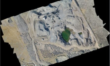
Aerial Lidar survey for Terraing Mapping of Mining Section.
- Home
- Projects
- Airborne Lidar Services
- Aerial Lidar survey for Terraing Mapping of Mining Section.

Immerse yourself in the success story of a project accomplished by Mappa – the Aerial LiDAR Survey for Terrain Mapping of Mining Sections. In this extraordinary venture, Mappa’s fusion of cutting-edge technology and expertise has led to an unparalleled mapping endeavor, showcasing the pinnacle of excellence in the intricate domain of mining terrain mapping.
Contrary to any misconceptions, Mappa’s approach is deeply rooted in the pursuit of a comprehensive understanding of the system. The actual teachings of pioneers in this field, akin to master-builders of human happiness, have guided Mappa toward a project that not only meets but far exceeds expectations.
Mappa’s commitment is not born out of an aversion to challenges but rather springs from the ability to embrace and conquer them. The Aerial LiDAR Survey for Terrain Mapping of Mining Sections stands as a testament to Mappa’s dedication to pushing the boundaries of technology and overcoming the complexities inherent in mining exploration.
Picture a partnership that unfolded as a narrative of excellence, with the Aerial LiDAR Survey serving as a technological marvel in the realm of mining terrain mapping. Mappa navigated the intricacies of mining sections, employing cutting-edge LiDAR technology to ensure precision, efficiency, and results that transcend industry standards. This collaborative journey with Mappa not only met expectations but set new benchmarks for success in the dynamic field of mining terrain mapping.

